The Dutchman's Hat and the Litorina Trail
The Dutch Cap and the Litorina Nature Trail
Olando kepurė ir nuo jos vedantis „Litorina“ pažintinis takas, greičiausiai, yra viena žymiausių vietų pajūryje. Čia, nuo 24 metrų aukščio skardžio, atsiveria panorama į Baltijos jūrą, o aplink supantys pušynai suteikia ramybės pojūtį. Išskirtinė gamta ir vaizdai, kurių niekur kitur Lietuvoje nepamatysite. Aplankyti šią vietą verta bet kuriuo metų laiku, nes kaskart atsiveria išskirtiniai pajūrio gamtos vaizdai.
Basic information
How to find us?
The centre of Palanga is about 20 minutes' drive away.
Parking at the Dutch Cap
Guests can leave their car in one of the nearby car parks upon arrival. During high season, parking in the main Dutch Cap car park can be difficult due to lack of space. If you can't find a space, you can leave your car a few hundred metres from this car park or in the large car park in Karkle.
Important: Parking near the Dutchman's Hat is metered year-round, from 8:00 a.m. to 8:00 p.m. The first hour costs €2.50, and each additional hour costs €3.50. Parking is free for electric vehicles. You can pay for parking in this zone using the UNIPARK app.
How long does it take to visit?
Pasižvalgyti ant skardžio įrengtoje apžvalgos aikštelėje ilgai neužtruksite. Tačiau nuo Olando kepurės prasideda „Litorina“ pažintinis takas, kurio ilgis apie 2,8 kilometro – praeiti šiuo taku nuo pradžios iki pabaigos užtruksite apie 1 val.
Dutch cap
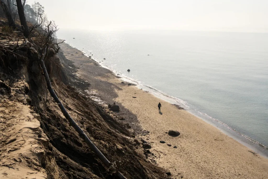
The 24-metre-high cliff between Giruliai and Karkle is known as the Dutch Cap, and is the highest point on the Lithuanian seaside. You can reach the cliff by following a forest path that leads to a viewing platform on the cliff. The views from here are breathtaking: the horizon of the Baltic Sea, the pebbly beach, the steep cliffs covered with tree roots.
Gamta šioje vietoje nuolat kinta: Olando kepurė turi ypatingai statų šlaitą, kuris po truputį slenka žemyn, taip pat poveikį turi jūros bangos, požeminiai šaltiniai. Manoma, kad ši vieta ilgainiui apskritai gali išnykti. Lankantis čia ir atidžiau apsižiūrėjus galite pamatyti vėjo ir vandens erozijos ženklus – tai tik patvirtina, kad vietos kraštovaizdis nuolat kinta.
An unusual place name, isn't it? It was named by sailors who, from the sea, were probably reminded of a Dutch-style old hat. For a long time, the locals called the place 'Black Manor', meaning 'black manor'.
Dutch hat - the story
It is thought that this cliff may have been formed around 12-15 thousand years ago by glacial drift.
The place on maps originated around the end of the 17th century when charts were drawn up for sailors. However, the site was also a landmark for sailors in the past: the forests of the area contrasted with the sands and were therefore visible from the sea. The name of the hill was formally established on maps around 1818.
In the 18th and 19th centuries, Dutch merchant ships plied the Baltic Sea, and the site is the site of many legends of ships wrecked on the coast during storms. Perhaps this is what led to the creation of the cemetery in Karklė.
The Litorina Trail
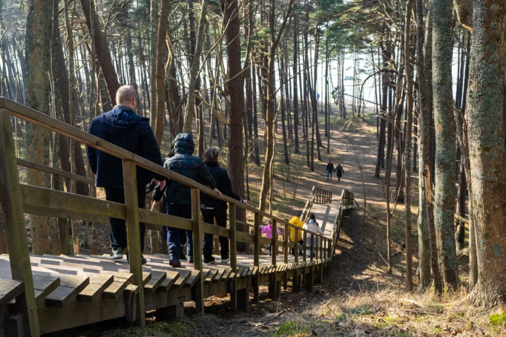
The 2.8 km-long "Litorina" nature trail starts from the Dutch Cap in the direction of Klaipėda. The trail is signposted by wooden stakes with arrows. You will also see information boards about the origin of the place and its vegetation.
It is a picturesque place for nature walks: it takes about 1 hour to complete the route, there are benches along the way, part of the walk is along the slopes overlooking the sea and the other part is through the forest. The path is not circular, so we recommend walking back along the seashore. Here you will see not only tree species typical of our region, but also ravines and slopes formed by springs.
The name "Litorina" is the name of the sea that used to be here 8 000 years ago. The water level of the Litorina Sea was much higher than that of the Baltic Sea today. So, when you walk along this trail, you will be walking along the shoreline of what was once a sea.
Frequently asked questions
Where is Olandas's Hat, and how do you get there from Palanga?
Olando Cape is located between Giruliai and Karklė, about a 20-minute drive from the center of Palanga. You can reach the cliff via a forest trail that leads to an observation deck built on the cliff.
How much does it cost to park at Oland's Hat?
Parking at the Dutchman's Cap is metered year-round, from 8:00 a.m. to 8:00 p.m. The first hour costs €2.50, and each additional hour costs €3.50. Parking is free for electric vehicles. You can pay for parking in this zone using the UNIPARK app.
Is it easy to find a parking spot near Oland's Hat?
During the high season, there may not be any spaces available in the main parking lot. In that case, please park your car a few hundred meters away from the main parking lot. There is also a greater parking lot in Karklė, but it's about a 20-minute walk from there to Oland's Hat.
How long does it take to visit the Dutchman's Cap?
Priklauso nuo to, ko norite. Vien nueiti ir pasižvalgyti nuo apžvalgos aikštelės užtruksite 20–30 minučių. Jei sugalvosite praeiti Litorinos pažintinį taką nuo pradžios iki pabaigos — apie 1–2 val.
How tall is the Dutchman's hat?
24 meters. This is the highest point on the Lithuanian coast. From the observation deck, you can see the horizon of the Baltic Sea, a rocky beach, and steep cliffs entwined with tree roots.
Why is this place called "Oland's Hat"?
Sailors gave the place its name—from the sea, the cliff reminded them of an old-fashioned Dutch-style cap. For a long time, the locals called it „Melnmuiže,“ which means „black manor.“ This name was officially recognized on maps around 1818.
How long is the Litorina Trail, and is it a loop?
The trail is about 2.8 km long and begins at Oland’s Cap, heading toward Klaipėda. The trail is not a loop, so we recommend walking back along the seashore. The route is marked with wooden posts bearing arrows, and there are benches and information signs along the trail.
What does the name „Litorina“ mean?
That was the name of the sea that existed here 8,000 years ago. The water level of the Litorina Sea was significantly higher than that of the present-day Baltic Sea, so when you walk along this trail, you are actually walking along what was once the seashore.
Is the Litorina Trail suitable for children and strollers?
The Litorina Trail is suitable for families with children—the 2.8-kilometer route is not difficult and is manageable for children. However, it may be more difficult with a stroller: although most of the trail follows a forest path, there are sections with wooden planks, uneven surfaces, and tree roots. It’s also worth noting that the 2.8 km route is one-way—going there and back along the same path makes for a total of about 5.6 km.
Is it safe to walk up to the edge of the cliff near Oland's Hat?
There is a safe observation deck with a safety railing next to Oland’s Hat, and there are well-trodden walking paths all around, so you can safely enjoy the view of the sea. However, you should not climb right up to the edge of the cliff, especially with children.
When is the best time to visit Oland's Cap?
This place is worth a visit any time of year—the seaside views are different every time. It’s quieter here during the off-season, and in the summer, it’s best to come early in the morning or in the evening, when there are fewer people at the parking lot.
What else is there to see near Oland's Cap?
Nearby is the wide, peaceful Karklė Beach. We've put together more ideas for day trips from Palanga in our overview TOP 6 places around Palanga.

Apartments in Palanga
Questions? Contact us!
Fill in the form. This is the quickest way to make a booking request.
Call us. We will advise and help you
+370 630 08558
Contact us at [email protected]